

AmeriGEO is the Americas chapter of the Group on Earth Observations (GEO), an intergovernmental association created by the World Meteorological Organization. Its purpose is to promote equitable access to Earth observation information to help decision-makers understand and act on the global challenges of climate change, biodiversity loss, and pollution, integrating scientific observation, local knowledge, and innovative technologies.
As part of the cooperation framework that serves 21 countries in the region, it annually convenes AmeriGEO Week to strengthen government capacities and promote the exchange of experiences. The 2025 edition, held in Bogotá, Colombia, brought together more than 1,500 regional and global attendees to discuss applied and open science, geospatial technologies, and energy and mineral resource management, among other topics.
AmeriGEO Week 2025
Science for Methane Mitigation
The importance of scientific measurements and satellite monitoring in advancing methane mitigation was the focus of the discussion among experts from Argentina, Brazil, Colombia, and Mexico.

As part of the AmeriGEO Week agenda, a plenary session entitled “How satellite-based systems and scientific measurements can drive methane mitigation” was held, organized by the International Methane Emissions Observatory (IMEO) of the United Nations Environment Programme (UNEP) and moderated by María Alejandra Garzón, technical coordinator of OEMLAC, representing OLACDE.
The session was attended by Dolores Barrientos, UNEP representative in Colombia; Ghisliane Echeverry, director of the Colombian Institute of Hydrology, Meteorology, and Environmental Studies (IDEAM); Florencia Carreras, IMEO Regional Case Manager; Santiago Nogueira and Abraham Ortínez, focal points of the Methane Alert and Response System (MARS) for Argentina and Mexico, respectively; Diego Suancha from the Hydrocarbons Directorate of the Colombian Ministry of Mines and Energy; Rodrigo Barbosa, energy efficiency and decarbonization manager at Petrobras; and Sara Castellanos, senior HSE and climate change professional at Ecopetrol.
During the plenary session, participants agreed on the importance of inter-institutional and intersectoral coordination, as well as satellite data and field measurements to accelerate regional climate action.
At the opening, Ghisliane Echeverry framed the conversation around the opportunity to move from data to decisions, highlighting how Earth observation expands coverage in remote territories and enables evidence-based public policies.
Florencia Carreras detailed initiatives such as MARS and OGMP 2.0, highlighted the support provided to countries in building their baselines, and pointed to examples of the effectiveness of reporting super-emitter events, which led to timely responses from O&G operators and national governments.
From a governmental perspective, Abraham Ortínez explained how the MARS focal point has enabled inter-institutional coordination in Mexico and accelerated the response to alerts, facilitating the institutionalization of the detection, reporting, action, and verification process.
At the subnational level, Santiago Nogueira presented how, in the Province of Neuquén, Argentina, notifications have become a management routine that has shortened the time lag between satellite data and on-site action.
Diego Suancha highlighted Colombia’s efforts to strengthen its legislative framework and how field measurement data used as input for the country’s baseline study has helped guide national planning for methane mitigation.
From the private sector, Sara Castellanos detailed the progress made in Ecopetrol’s transition to direct measurement and the development of top-down campaigns, following the OGMP 2.0 standard, as well as the scientific studies carried out and the upcoming launch of a study focused on methane emissions from abandoned wells.
Finally, Rodrigo Barbosa recounted Petrobras’ experience in implementing its plan to advance from Level 4 to Level 5 in the OGMP 2.0 standard, the challenges in monitoring emissions in offshore exploitation, and the strategy defined to make use of satellite information for emissions detection.
“Through the work we have been carrying out at OEMLAC—and which we have demonstrated across the region—there has been a tangible opportunity for stakeholders to join forces to promote climate transparency, strengthen the means of implementing climate action, and advance the conditions that drive such action.
Within this context, science, technology, and innovation play a fundamental role in finding solutions that are cost-effective, that integrate the strengthening of climate governance, and that enable us to act more swiftly during this critical decade.”
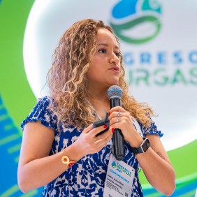
Alejandra Garzón
Technical Coordinator of OEMLAC